Important facts
- What does the EUDR require in relation to geodata?
- Exact geo-coordinates of the original area must be available for each unit of goods concerned.
- Why is geodata so important?
- They serve as objective proof that there is no deforestation or illegal origin.
- Who is responsible for the geodata?
- Every market participant must ensure the completeness and accuracy of the geodata.
- What happens if geodata is missing?
- The product may not be placed on the EU market without geo-data and EUDR reference number.
- How can companies implement geodata efficiently?
- Digital tools, clear processes and supplier contracts help with secure recording and transfer.
Executive Summary
The EUDR places the precise collection, documentation and transfer of geodata at the heart of compliance requirements. Companies that import raw materials such as soy, coffee, palm oil or wood into the EU must prove exactly where their products were produced. Together with an EUDR reference number, geo-coordinates provide objective proof of deforestation-free supply chains and form the basis for official inspections and automated risk analyses.
Downstream traders in particular face major challenges: They have to organize, contractually secure and check the plausibility of geodata for collective deliveries of various origins, often without direct access to the areas of origin. If the data is missing or incomplete, there is a risk of import bans, product seizures and fines in the millions.
Geo-data is not a "nice-to-have", but the key to EUDR compliance. Companies should firmly integrate it into supplier contracts, quality management systems and internal processes, supported by digital platforms that automate data collection and management of EUDR reference numbers.
Geodata in the EUDR - what is required?
Obligation to provide coordinates
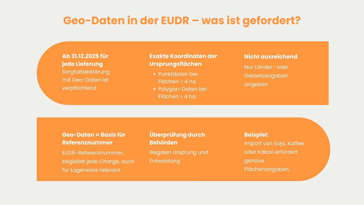
The EUDR stipulates that a due diligence declaration must be available for every relevant product sold on the Union market after December 30, 2026. This due diligence declaration must include the precise geo-coordinates of the agricultural or forestry land on which the raw material was produced. It is not sufficient to simply provide the country of origin or a vague description of the area. The coordinates must be provided digitally either as point data (for smaller plots of less than four hectares) or as a polygon (for larger areas) in accordance with the requirements of the EUDR Regulation.
This geolocation data is not only mandatory for every batch or consignment. They also serve as the basis for the unique assignment of EUDR reference numbers in digital systems. This allows authorities to check at any time whether raw materials or products made from them (relevant products) are associated with illegal deforestation and forest degradation. In practical terms, this means Anyone importing coffee from Brazil, cocoa from the Ivory Coast or soy from Argentina, for example, must prove exactly on which area and at what time the production took place.
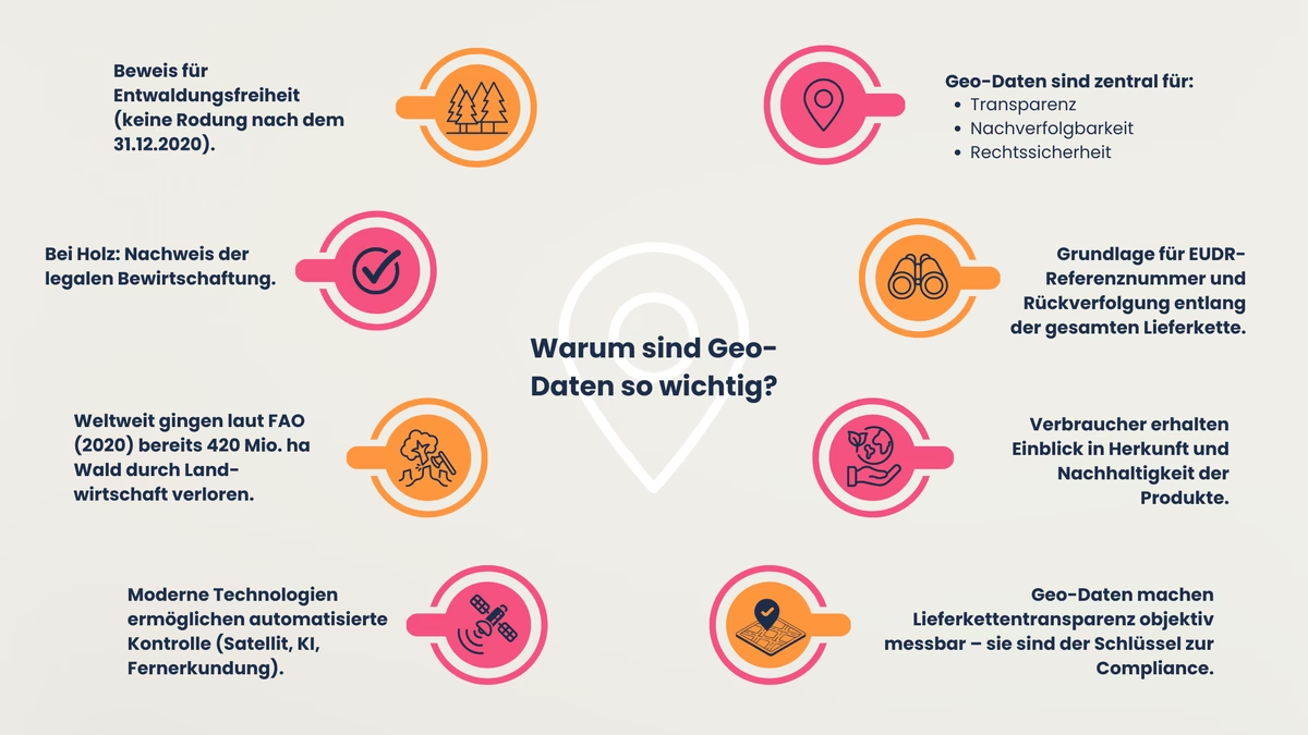
Why is the use of geodata so important?
Geodata plays a central role in the implementation of the EU regulation on deforestation-free supply chains (EUDR) because it forms the basis for transparency, traceability and legal certainty. Only by providing precise geo-coordinates of the agricultural or forestry production areas can it be clearly proven whether a product originates from an area that was not cleared or deforested after the cut-off date of December 31, 2020. In the case of wood, the information also serves to verify whether the cultivation was legal.
The EUDR requirement is not purely theoretical:
According to a 2020 report by the Food and Agriculture Organization of the United Nations (FAO), around 420 million hectares of forest worldwide have been converted into agricultural land in the last three decades. This is almost equivalent to the area of the entire EU.
The EUDR addresses precisely this ecological problem and uses modern technologies for monitoring and tracking. Thanks to digital geodata, satellite images, drone images and other remote sensing data can now be analyzed automatically, often with the help of artificial intelligence. This allows authorities to quickly, efficiently and objectively check whether a supply chain complies with legal requirements. This also gives civil society actors and independent organizations new opportunities for verification.
However, geodata is not only of central importance for authorities. They also form the basis for assigning the so-called EUDR reference numbers. They are a digital identification feature that clearly assigns each product placed on the market to its area of origin. These reference numbers accompany the goods through the entire supply chain all the way to the retailer and create a new level of traceability.
For consumers, this means that in future they will be able to better understand where the products they consume come from and whether their production complies with environmental and social standards. Geodata will therefore enable a new era of supply chain transparency that goes far beyond mere documentation requirements. It is the backbone of a system that makes sustainability measurable and verifiable and therefore the key to EUDR compliance.
Challenge for downstream retailers
How retailers handle geodata
For companies that work directly in the field or in the forest, such as agricultural producers or loggers, collecting the necessary geodata is generally easy to implement. They know their areas and can use GPS devices, satellite maps or geographic information systems (GIS) to record exactly where their raw materials were produced. This data and content can be documented relatively easily and made available as part of the EUDR.
However, it is much more difficult for downstream players. These include traders, middlemen, importers or processors who do not purchase their raw materials directly from the producer. They often purchase so-called collective deliveries, where the goods come from many different areas of origin, sometimes even from several countries. In these cases, it is almost impossible for the retailer to tell which product comes from which area.
What does the EUDR stipulate?
For each individual product unit that enters the EU, the area from which it originates must be fully documented, including exact geo-coordinates and the corresponding EUDR reference number. This applies regardless of how many intermediate stations the goods have passed through.
For retailers, this means that they must ensure that they have all the necessary information for each batch in full and correctly. This includes not only the pure EUDR geodata, but also checking whether this data is plausible, up-to-date and authentic.
The effort involved is enormous, as this is particularly challenging in global supply chains with many participants and little direct contact with the original producers. The longer and more complex the supply chain, the greater the risk of gaps, ambiguities or incorrect information.
This is why retailers need new processes, digital solutions and often also partnership agreements with their upstream suppliers in order to reliably fulfill their EUDR obligations. After all, only those who correctly document and secure all geo-data can prove that their supply chain is EUDR-compliant in the event of an inspection. If the geo-data is not available, in the worst case scenario the product cannot be imported into the EU and sold here.
Transparency vs. data protection
A particularly sensitive area of tension arises between the legitimate interests in supply chain transparency on the one hand and data protection on the other. Geodata often contain conclusions about ownership, internal company structures or, in the case of small farmers for example, personal data. In the context of the EUDR, transparency obligations and the right to data protection should be observed here. In practice, the geocoordinates are therefore transferred in full to the due diligence declaration and the digital EUDR platform. When forwarding in trade, care is taken to ensure that the EUDR reference number is anonymized. Authorities and inspection bodies then have access to the raw data if required, while the internal flow of goods remains traceable via the EUDR reference number.
Important: Without underlying geodata, the EUDR reference number is worthless.
What to do if the supplier does not provide geodata?
Consequence of missing information
If the required geodata for a product is missing, i.e. the exact coordinates of the area of origin and the corresponding EUDR reference number, the goods may not be traded further in Europe. This applies to all companies along the supply chain, in particular traders, importers and processors. They may only resell or import products for which complete and verified documentation is available.
Anyone who nevertheless puts products into circulation without complete geo-data risks serious legal consequences. The competent authorities of the EU member states are obliged to consistently pursue infringements. They can not only confiscate products with incomplete information, but even permanently exclude them from the market. The competent authorities may also carry out on-site inspections in third countries in accordance with Article 18(2)(e) of the EUDR, provided that the third country agrees.
The potential financial consequences are also serious: According to the EU Commission, serious infringements could result in fines of up to 4% of the total annual turnover generated by a company in the EU. Depending on the size of the company, this can quickly amount to millions.
There is also the potential for reputational damage: Companies that violate the EUDR quickly come under the scrutiny of authorities, NGOs and the public. Especially in times of increasing transparency requirements, such a case can have a significant impact on the trust of customers, partners and investors.
Conclusion: Without reliable geo-data and an EUDR reference number, legally compliant trade in the EU is no longer possible. Companies should therefore ensure at an early stage that they have complete information and, if in doubt, prefer to forego a delivery rather than take a risk.
Responsibility of the market participant
The EUDR makes it clear that every market participant, including retailers, importers and processors, is responsible for checking and correctly documenting the geodata of their products. It does not matter how far away they are from the actual place of production. The length or complexity of their supply chains are not decisive factors.
In practice, this means that companies must work closely with their suppliers. They should clarify at an early stage that their suppliers will provide all the necessary geodata completely, correctly and on time. The best way to do this is by contract in order to create clear rules and obligations for all parties involved. Only if the geodata is passed on reliably can the EUDR reference number be correctly assigned and carried throughout the entire supply chain. This reference number is crucial for proof of origin and legality.
But simply passing it on is not enough:
Retailers and processors must also check the plausibility of the data received. For example:
→ Random samples of individual deliveries
→ Risk assessments by country of origin or supplier
→ The use of digital tools with map views or
→ Comparison with satellite images, e.g. to identify deforestation
If there are doubts about the accuracy of the data, for example because something does not match or remains unclear, companies should rather refrain from making the delivery in question. This is because incomplete or incorrect geodata can lead to legal and financial problems later on.

SMEs and geodata - what applies here?
For many small and medium-sized enterprises (SMEs), implementing the EUDR requirements is particularly difficult. They often lack digital solutions for collecting geodata, sufficient staff to take care of this or expertise in using map and GIS systems and digital supply chain platforms. Nevertheless, the EUDR only makes a few exceptions. Even SMEs must provide precise geodata on origin when importing or trading affected goods such as soy, coffee, wood or palm oil. The obligation to provide coordinates and use the EUDR reference number therefore applies to everyone.
Although there are somewhat reduced obligations for SMEs, this does not change the fact that the origin of the products must be clear and verifiable.
If SMEs act as downstream market participants or traders, these products are already covered by a DDS. In this case, SME traders are not required to provide additional geolocation data or issue new DDSs. In particular, SME traders must document the DDS reference or verification numbers and buyer/seller information, keep them for five years and pass them on to buyers or authorities on request.
Depending on the size of the area, point or polygon data is required (from >4 ha usually polygon). The data is typically transmitted in standardized formats such as GeoJSON. However, you must keep the information collected and the due diligence declaration for at least five years. If, on the other hand, the SME places the products on the market itself, it must provide the DDS including the geodata itself.
So what can SMEs do?
- Joining forces, for example in cooperatives, associations or industry networks
- Use specialized service providers to help with the digital capture and verification of geodata
- take advantage of support programs, for example from chambers of industry and commerce, trade associations or EU initiatives. These often offer advice, training and technical support
In this way, smaller companies can also meet the requirements of the EUDR: more efficiently, together and with less effort.
Practical implementation and recommendations for action
Creating contractual clarity
Companies are well advised to make clear, written agreements on the delivery and accuracy of the required geodata when selecting and managing their suppliers. Supplier contracts should specify exactly how, when and in what form the coordinates are to be handed over and that the data must correspond to reality. At the same time, a legal framework should be defined in the event that geodata is missing or is subsequently identified as incorrect. This includes liability regulations, warranty periods and the obligation to correct incorrect data immediately and ensure the flow of reference numbers. Example: A medium-sized coffee importer in Hamburg has concluded contractual clauses with its Brazilian suppliers according to which each shipment is only accepted with complete geo-coordinates of the respective plantation. The agreement also provides for a contractual penalty in the event that incorrect or manipulated EUDR geodata is discovered during external inspections.
To Do: Specify in supplier contracts the binding form in which geodata is to be supplied, including liability regulations and contractual penalties for incorrect or missing information.
Use of digital tools and platforms
The technical implementation of EUDR requirements is most efficiently achieved with modern digital tools that are specifically tailored to supply chain management and supply chain tracking. Special supply chain or EUDR management platforms, such as our lawcode suite, make it possible to automatically record and validate geodata and assign it to the corresponding consignments. This enables all supply chain participants to digitally document sustainable standards and adopt the EUDR reference number as a unique digital identity.
Our solution also offers import and export interfaces to ERP systems and merchandise management software in order to efficiently integrate the data flow into existing process landscapes. It can also be used to carry out geographical risk analyses and provide objective evidence for due diligence, which can be convincingly communicated to authorities and stakeholders. In practice, it has been shown that digital platforms for recording geodata can significantly reduce administrative costs.
To Do: Rely on specialized EUDR management platforms that automatically capture, validate and link geodata with EUDR reference numbers, ideally with an ERP interface for seamless integration into existing processes.
Training and process anchoring
It is not enough for companies to rely solely on technology or contracts to be able to meet the requirements of the EUDR in the long term and reliably. It is equally important that the handling of geodata is firmly anchored in internal processes. This includes, above all, providing employees with targeted training. Everyone who works with the products concerned should understand why geodata is so important and how it is correctly recorded, checked and passed on. Training courses should therefore not only teach the technical basics of geodata and GIS systems, but also cover the legal principles of EUDR, data protection and the obligation to provide evidence.
In addition, the collection, verification and documentation of geodata, including EUDR reference numbers, should be an integral part of internal processes. Ideally, this process should be integrated into existing structures such as the quality management system. This ensures that there are no gaps if something changes in the company, for example due to a change of personnel, new suppliers or changes in the flow of goods. Audits in particular closely examine whether the handling of geodata in the company is organized in a permanent, comprehensible and systematic manner. Sustainable EUDR compliance can only be established with clear processes and responsibilities.
To Do: Train all relevant employees on geodata, EUDR requirements and data protection and anchor the collection and verification of data as an integral part of the quality management system.
Conclusion
Geodata is no longer a voluntary sustainability measure, it is a binding requirement for market participation. Only those who can prove exactly where their products come from will meet the EUDR requirements and prevent environmentally harmful goods from entering the EU.
The EUDR reference number alone is not enough. Without verifiable geodata, it loses its value as proof of authenticity. Companies must therefore establish systems that guarantee the permanent and reliable collection, transfer and updating of data, because geodata can only retain its regulatory and practical relevance with high data quality.
Frequently asked questions
In the context of the EUDR, geodata refers in particular to the exact geographical coordinates (longitude and latitude) of the original area on which a raw material was cultivated, extracted or harvested. Depending on the size of the area, this must be either a single point or a precisely delimited polygon describing the cultivation or production area. Addresses, parcel numbers or mere area descriptions are explicitly not sufficient to meet the legal requirements.
As a retailer, you are responsible for ensuring that you have the required geo-data and the corresponding EUDR reference number for each unit of goods sold. Physical access to the production areas is not mandatory, but the obligation to have authentic and complete information from all upstream suppliers documented is. Missing evidence leads to compliance violations, regardless of your position in the supply chain.
For monitoring purposes, authorities access the geodata and EUDR reference numbers transmitted and compare them with satellite images, remote sensing data and cartographic information sources. In the event of deviations or suspicions of deforestation, physical inspections or in-depth queries can be carried out. Automated reconciliation systems with AI-supported monitoring solutions help inspectors to detect irregularities at an early stage.
Yes, in principle, the obligations of the EUDR and thus the requirement to provide professional geodata including reference numbers also apply to small traders and SMEs, provided that the types of goods listed in Annex I of the Regulation are traded. However, SMEs do not have to provide additional geodata if a DDS is already available. This applies to SME market participants in the downstream supply chain, such as small traders. However, the goal of complete traceability remains.
Reliable quality assurance is achieved through a combination of digital plausibility checks, map comparisons, risk analyses and, if possible, on-site spot checks by third parties or independent auditors. Ideally, retailers should use digital tools that enable automatic checks based on up-to-date satellite data. It is also advisable to continuously raise awareness and train all suppliers on the importance of data quality and transparency.

Karim Boukaouche
LinkedInESG-Compliance Experte · lawcode GmbH
Karim Boukaouche berät Unternehmen bei der Umsetzung der EU-Entwaldungsverordnung (EUDR) und begleitet die Implementierung digitaler Lösungen für rechtssichere Lieferketten. Seine Fachbeiträge auf dem lawcode Blog verbinden regulatorische Tiefe mit praxisnahen Handlungsempfehlungen.